Mozambique Uses AfDB-Financed Drone Technology to Respond to Devastating Floods
Mozambique has deployed advanced drone technology financed by the African Development Bank Group to support search and rescue operations and disaster assessments following some of the most severe floods the country has experienced in recent years.
The drone operations are being carried out under the Drone-Based Disaster Management Project, financed by the African Development Bank through the Korea–Africa Economic Cooperation (KOAFEC) Trust Fund and implemented in partnership with the Government of Mozambique and Busan Techno Park. The initiative was launched in April 2025 to strengthen national disaster preparedness and response capacity.
Between 9 and 26 January 2026, floods affected more than 692,000 people across the country, claiming 12 lives, damaging over 1,300 kilometres of roads and forcing the postponement of the school year to 27 February. Gaza Province has been the worst affected, with the provincial capital, Xai-Xai, largely submerged and key road networks destroyed, cutting off access to several communities.
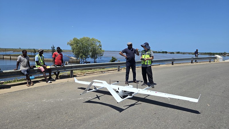
This week, a response team comprising Mozambican government officials and Korean technical experts began drone missions in Gaza Province, including the districts of Chókwè and Guijá. The drones are being used to identify stranded residents and transmit their locations in real time to emergency coordination centres, enabling faster and more targeted rescue operations.
The scale of the damage has raised concerns about a potential food security crisis. More than 34,000 livestock have died, while over 100,000 hectares of farmland have been destroyed, compounding the humanitarian impact of the floods.
Drone deployments followed high-level coordination meetings held on 26 January 2026, which brought together the Mozambican government, African Development Bank officials and a Korean technical team to align response efforts.
Minister of Communications and Digital Transformation, Américo Muchanga, said the initiative marked a turning point in the country’s disaster response strategy.
“This initiative represents a pivotal moment in our national strategy as we develop a skilled workforce capable of leading disaster response with confidence and autonomy,” Mr Muchanga said. “By putting this technology into action, Mozambique is strengthening its ability to protect communities during severe climate-driven emergencies.”
To ensure long-term impact, the project has donated nine drones to Mozambique, including four training drones and five operational drones. These assets will allow authorities to monitor high-risk areas as weather and environmental conditions evolve. Twenty Mozambicans, including staff from disaster management agencies and security services, have completed specialised drone training and are now flying missions alongside Korean experts.
African Development Bank Resident Representative in Mozambique, Rômulo Corrêa, said the Bank was fully engaged in supporting the country during the crisis.
“Our priority is to ensure that emergency teams have the tools and information they need to reach people quickly and save lives,” Mr Corrêa said. “By moving from training to active drone operations, we are providing real-time data that shortens response times and reconnects isolated communities. In the long term, this approach will also strengthen Mozambique’s resilience to future disasters.”
Busan Techno Park President Kim Hyeong-kyun said the flood response demonstrated how technology-based cooperation can deliver immediate results during emergencies.
“This response shows how the outcomes of the drone-based disaster management project can be applied directly in a real crisis,” he said. “We will continue to play a role as a global partner in technology-driven international cooperation and public responsibility.”
Drones are increasingly recognised as a vital tool in disaster response, enabling faster and safer operations in flooded or inaccessible areas. By providing detailed aerial imagery, they help authorities prioritise rescues, plan access routes, assess infrastructure damage and monitor evolving risks.